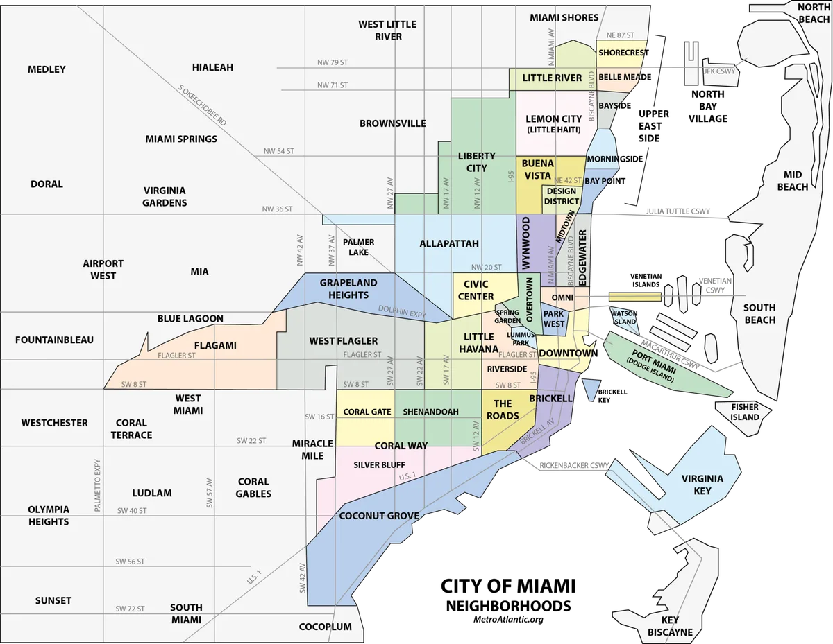
Newcomers to Miami usually arrive with three neighborhood names on their lips and a map app full of contradictions. That is normal. Miami's neighborhoods shift, rename, and blur at the edges, and even longtime locals argue about where one ends and the next begins. The fix is an old fashioned one: start with the map, not the listings.
This guide explains why Miami's map looks the way it does, names the areas worth knowing first, and offers a simple method for exploring the city like someone who lives here. The method is simple, free, and mostly involves comfortable shoes.
Why the Map Comes First
Miami was founded in 1896, and as Wikipedia's list of Miami neighborhoods notes, many of the city's neighborhoods have been renamed, redefined, and changed since then. The exact extent of some areas differs from person to person. Real estate marketing adds new names faster than maps can absorb them, so a newcomer who trusts listings alone will soon be lost.
The city itself is compact. Miami proper counted 442,241 residents at the 2020 census, according to Wikipedia's city profile, and the city takes its name from the Miami River, whose own name traces back to Mayaimi, the historic name of Lake Okeechobee. A compact, storied city rewards wandering more than driving.
The Constant and the Changing
A few anchors have held steady. Brickell sits at the center of the Miami core, with Interstate 95 to the west, Brickell Bay to the east, the Miami River to the north, and the Rickenbacker Causeway to the south. Coconut Grove, first settled as Cocoanut Grove, has kept its name and character largely intact since its early settlement in 1825.
Other names moved around. Buena Vista was once much larger in the 1920s than it is today, taking in what is now the Miami Design District and parts of Little Haiti, Wynwood, and Edgewater. The Arts and Entertainment District was previously branded Omni, after the mall that stood there in the 1980s and 1990s. Midtown emerged as a new neighborhood in the mid 2000s, after developers built the large Midtown Miami project in an area traditionally known as Edgewater. Readers following this should also see Little Haiti's cultural renaissance: a neighborhood guide to the art, the kitchens, and what comes next.
The Areas Worth Knowing First
- Brickell: the financial core, high rise and bayfront, where office towers meet the water.
- Coconut Grove: leafy, low rise, and village like, with a long waterfront of its own.
- Wynwood: the gallery and murals district north of downtown, built from former warehouses.
- Little Havana: the Cuban exile heart of the city, west of downtown along Southwest Eighth Street.
- Midtown and the Design District: shopping, art, and a live lesson in how fast new names appear.
How to Explore Like a Local
Pick one neighborhood per outing and walk its main street end to end before you decide anything. Note where the feel changes, not just where a map line sits. Talk to shopkeepers; they will give you the real borders in one sentence. And when a listing borrows a glamorous neighborhood's name, check the address against the map, because in Miami the label and the location do not always agree.
The map first habit also guards against the most common newcomer mistake: choosing a home by neighborhood name alone. Two streets under the same label can feel like different towns, one busy and glassy, the other quiet and tree lined, and only your own feet will tell you which one you want. This connects to our earlier piece, Downtown Miami vs. Midtown: same criteria, different numbers.
Conclusion: Learn the Map, Then Make It Yours
Miami's neighborhoods resist tidy boundaries, and that is part of the city's charm. Anchor yourself with the stable names, stay curious about the shifting ones, and let the map guide your first months. The city rewards newcomers who explore on foot, ask questions, and treat neighborhood lines as conversations rather than facts.